 The Brazilian Amazon’s social and environmental history in the last forty years has been governed by the completion of monumental infrastructure projects, especially in transportation and energy generation. Over the years, research on the operation of the energy sector has brought to light the impact it has on the environment and how it affects the population living within its orbit.
One recurring point in these studies is the enormous influence that construction, hydroelectric projects, mining companies, agro-industry and oil, gas and forestry extraction wield on state development policies and practices. These companies often exercise considerable leverage on decision making process in areas that are usually and formally designated to be in the political sphere. The State’s apparent inability to establish a standardized best-practice procedure to ensure consultation with the indigenous, quilombola[1] and traditional[2] populations seems to be the result of these partially hidden interests, hierarchies, and regulations involved in this complex relationship.[3]
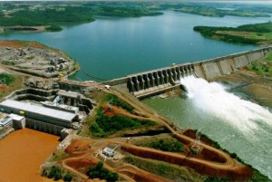
What Harvey commonly referred to as “accumulation through dispossession” is not uncommon in the Amazonian theatre. Capital “acquires” swathes of new territory and denies the indigenous population living there access to their land and water. The Environment is thus symbolically and materially downgraded exclusively into the commercial realm and becomes nothing more than a commodity injected into the wider global market to assist production and serve economic growth. This inevitably triggers currents of human migration as the usual means of subsistence of the traditional and rural populations (be they indigenous, quilombolas, or ribeirinhos[4]) are affected and they are forced to dislocate. Furthermore, as the fight for control and ownership of land intensifies, the deforestation process accelerates in order to ensure the establishment of a monoculture of agricultural crops (like soja, sugar cane, eucalyptus, etc.) Blatant land speculation is also common. In most cases the natural flow of the rivers is altered and creates multiple crises of access to, and supply of, water, not only for human consumption but also for other means of subsistence (the Belo Monte Dam is a prime example of such as case). Consequently, there is a direct and systemic impact on the food chain, and in particular on river fish. Undisposed of vegetation begins to decompose and produces methane emissions (a greenhouse gas) which is not only released into the atmosphere but also contaminates the water reservoirs by introducing pathogens and vectors which interfere with the dissemination of diseases such as malaria. This has resulted in an increase in infectious disease, and an exponential rise in STDs has been recorded.
The lack of planning is coupled with a blatant disregard for the constraints and provisions attached to the granting of the licenses. This has resulted in a fragile public health care system and an accompanying rise in the cost of living, especially in housing and food. Mitigating and/or compensable measures taken by either by the energy companies or by the public sector are retrograde and insufficient, implemented much too late to remedy any negative effects on the indigenous populations. It is not unusual for the incidence of violence to increase dramatically in the affected communities. The instances of death attributed to violence or accident have also increased substantially.
The transmission and distribution of the power generated by the hydroelectric plants, in the form of massive power cables, provide yet another cause for concern due to their substantial and multifaceted social and environmental impact. Even in the so called “usinas plataforma,”[5] the energy must be connected to the main regional or national grid, and this occurs on land, either by taking advantage of the already deforested routes (along the highways) or through the clearing and subsequent maintenance of new byways. It is estimated that there will be a need for hundreds of kilometres, and these newly cleared pathways will pass through conservation areas, indigenous territory and private property.
The saga of the Apinayé, who inhabit an area known as “Bico do Papagaio” (Parrot’s beak) in the Amazonian state of Tocantins, illustrates this history of territorial dispossession. For the past fifty years, they have watched their territory and way of life be diminished through the creation of various infrastructure projects, among them the Carajás and Norte-Sul railways, the BR 153, Transamazonian, TO 126 and TO134 highways, the high voltage line from the Tucuruí Hydroelectric plant, the environmental reverberations from the plants at Estreito and Lajeado, as well as the new waterways built on the Tocantins/Araguaia rivers. To this one can add the future dangers posed by the proposed dam at Serra Quebrada, which threatens to flood over 14% of land legally designated as Apinajé IT. They are furthermore confronting an accelerated program of deforestation promoted by companies such as Sinobrás (mining), Eco Brasil Florestas S/A (cellulose production), Cargil Agricola S/A (US Agribusiness exporter), Suzano Papel e Celulose S/A (pulp and paper). These companies are aided and abetted by the Instituto de Natureza do Tocantins (Naturatins, the Nature Institute of Tocantins) and encouraged to invest in the planting of soya, sugarcane, eucalyptus and plan to establish coal mines in the extreme north of the state of Tocantins.
This process and its consequences has been observed and recorded in various instances and situations not only across the Brazilian Amazon, but also in other areas both in Brazil and across the world.[6]
Hydroelectric plants in the Amazon: Effects on Indigenous Territory
Ignoring all recorded evidence and submitted objections, the Plano Decenal de Expansão de Energia 2023 (Ten Year Plan for Energy Expansion 2013, or PDE 2023) projects an increase of 28,000 megawatts in energy production in the decade from 2014-2023 through the coming online of several large scale hydroelectric plants. It does not, however, predict that any of the 30 plants throughout the country will have any direct impact on the indigenous territories. The plan states that eleven of the thirty will be situated at least 40 km from indigenous territory in what is known as “the Legal Amazon” and at least 15km away in the remaining regions. The plan is underpinned by an official decree known as the Portaria Interministerial no. 419/2011, which regulates the actions of federal public bodies dealing with the issuing of federal environmental licenses. However, the plan acknowledges that up to eight different indigineous territories will be affected by the 232 new transmission lines these plants will require, which combined add up to a total of 41,000 km of new lines. [7]
Collating the facts and information available in the Institute of Socioeconomic Research (Inesc) under the title “Rights and Investment in the Amazon,” we were able to ascertain that a collection of twenty-three hydroelectric power stations located in a minimum of seventeen infrastructure developments, have socio-environmental consequences on indigenous territories, be it on the populations that live there or on the physical environment that these populations are dependent on to maintain and further develop their way of life.
The discrepancy regarding the extent of the projected impact on the ITs between our study and the official version revolves around how the concept of “impact or interference” is constructed and defined. According to the current legislation, an “interference in IT” occurs when a parcel of IT land is directly affected by the dam’s barrier or by the reservoir. The criteria for defining and measuring “impact” concerns territorial and environmental effects only and does not include a human or social dimension. It is our position that it is both urgent and imperative that this indicator be revised.
Where indigenous communities are concerned, there are many studies indicating that the indirect impacts of such large scale developments are as negative or often even more so than direct impacts. The mere announcement that such a project is in the pipeline in the vicinity, often accompanied by sightings and even contact with surveyors or researchers is enough to provoke intense disquiet and anxiety amongst the Indian community. The situation in the Tapajós basin is one such example.
Studies undertaken in the last few decades show clearly that the interference caused by such massive projects reach far beyond the 10km radius around it. It can affect indigenous communities long before they have had any sort of direct contact with the project– that is to say, long before they come face to face with the life on margins of the construction of dams, railways, or the erecting of transmittors. As was explained by Daniel Posey in 1987, contact can be classified in three different ways:
- Indirect contact, which includes the transmission of disease without a human carrier through insects and animal vectors and depositories
- Intermediate contact, which depends on a temporary or fortuitous contact with groups or individuals such as merchants, soldiers, researchers, civil servants, miners, rubber tappers, and other indigenous people who have already had contact with other people and their diseases
- Direct contact, which, as suggested, is a result of cohabitation with missionaries, permanent civil service staff installed in the community, tourists, or even permanent personal relationships such as marriage with those who have already had a long period of life in urban centres or among those who have.
The collection of articles edited by Martin Alberto Ibańez-Novion and Ari Miguel Teixeira Ott in 1987 and the bibliographical study by Julio C. Melatti (1987) and that of Dominique Buchillet (2007), added to the information collated in A Map of Famine Among Indigenous Populations of Brasil by Verdum (1995) as well as the National Inquest into the Health and Nutrition of Indigenous People (Coimbra Jr., 2014), reveal the complex realities of the present situation of the indigenous populations and, more importantly, provide irrefutable clues to investigate the correlation between territory, governance, socio-environmental change, and the physical and emotional health of the indigenous communities throughout the Amazon region.
Final considerations
The complex tableau of threats and vulnerabilities suffered by indigenous people becomes even more serious given that their territorial rights continue to be disrespected on a massive scale in direct contravention of the fact that these have been legally recognized. Unfortunately, it seems that the “Terra Indígena” exists on paper only, as the Brazilian State does not guarantee these populations their human rights or any form of material security. In order to discourage the constant invasions of their land and to put an end to the resultant environmental degradation, the State must make is presence felt in these areas in an adequate and effective manner. The National Foundation of the Indian, FUNAI, has been hit year upon year by massive and systemic budget cuts. As a result, the services it can afford to provide have dwindled, and its political power in areas that are clearly within its remit, such as adopting a researched and informed position vis-à-vis the socio-environmental consequences on any of the Indigenous Territories of the many proposed infrastructural projects, has been categorically usurped. This is a clear violation of the territorial rights of the indigenous people of Brazil, a practice one sees occurring in a systematic and generalized manner not only in the Amazon, but also throughout the country.
Translated by Isabella Weibrecht
| Power Station | State | River | Impingement |
|---|---|---|---|
| Prainha | AM | Aripuanã | No registry available |
| Cachoeira Caldeirão | AP | Araguari | No registry available |
| Ferreira Gomes | AP | Araguari | No registry available |
| Santo Antônio do Jari | AP | Jari | There are three ITs in the basin area of the Jari River: two to the east and one to the west, and occupying about 10% of the basin’s area. Inhabited mainly by two tribes: the Waiãpi (Waiãpi IT) and the Aparai-Wayana (Parque do Tumucumaque and Rio Paru D’Este ITs). The Waiãpi are the main focus of the study because their territory as well as their settlements fall within the limits of the basin. The ITs of the Aparai-Wayana and their settlements technically fall within the limits of the Paru de Este River, which is to the west and adjacent to the river basin of the Jari. Only a very small section of their land is within the Jari basin at the head of the river and along smaller estuaries on its right hand side. Consequently this IT was not considered in the licensing documents for the power station. |
| Estreito | MA/TO | Tocantins | Krikati IT (MA) and Apinayé and Kraolâdia ITs (TO) |
| Marabá | MA | Tocantins | Mãe Maria IT, in Bom Jesus do Tocantins, will suffer considerable damage as the area that will be flooded is rich hunting ground and also the source of a tree specimen used to make arrowheads. This settlement has already suffered substantially from the construction of the Carajás railway, the BR-222 highway, and the erection of two Eletronorte power lines and a mobile phone mast. It is arguably the IT that has been most impacted by new infrastructure projects in Brazil. The resumption of the Marabá project in 2001 has put families belonging to the Gavião tribe on high alert. Two other territories are in danger: Sororó IT, inhabited by the Suruí, in São Geraldo do Araguaia (PA) and Apinayé Tocantinópolis IT, inhabited by the Apinayé in Mauritânia do Tocantins, São Bento and Cachoeirinha (TO). |
| Serra Quebrada | MA | Tocantins | Apinayé IT. |
| Castanheiras | MT | Arinos | No registry available |
| Colider | MT | Teles Pires | Kayabi IT and Munduruku IT. |
| Dardanelos | MT | Aripuanã | According to the report by the anthropologist Gilberto Azanha (CTI, 2004), the resulting impact of the “opportunities” offered by the project on the Cinta Larga (Aripuanã IT and Serra Morena IT) and the Arara (Rio Branco IT) would be as follows: (1) a significant increase in population in the Aripuanã municipality resulting in an increase in deforestation in those ITs, leading to the rapid depletion of commercial timber and the consequent demand for additional resources by illegal means, with or without the consent of the ITs, within the boundaries of the territories (2) an increase in the population of the city of Aripuanã and in Conselvam district leading to a increased demand for fish and game,already victims of illegal poaching within the ITs (3) a proliferation of mining companies taking advantage of reduced “opportunity costs” available (cheaper energy, larger and more efficient road network, etc), pillaging the terrain of the ITs and polluting the smaller tributaries and diminishing its fishstock. |
| São Manoel | MT | Teles Pires | According to information available from the licensing documents, the impacted ITs are Kayabi, Munduruki, Pontal do Apiaká and isolated Indians. The environmental impact report states that the dam’s reservoir will occupy an area slightly less than 6,600 hectares (66km2), encroaching on land in the municipalities of Paranaíta (MT) and Jacareacanga (PA). The area of indirect influence includes the ITs Kayabi and Munduruki, some 150km downriver, as well as that of IT Pontal dos Apiaká for which there are records of Indians living in isolation. The IT Kayabi is within the area of direct influence, less than 2km from permissible limits. |
| Sinop | MT | Aripuanã | No registry available |
| Belo Monte | PA | Xingu | Juruna KM17, Paquiçamba, Arara da Volta Grande, Trincheira Bacajá, Koatinemo, Kararaô, Apyterewa, Araweté Igarapé Ipixuna, Arara, and Cachoeira Seca ITs all affected. |
| Cachoeira dos Patos | PA | Jamanxim | Information available in the licensing documents does not yet indicate which territories will be affected by the project. |
| Jamanxim | PA | Jamanxim | Praia do Índio, Praia do Mangue, Sãó Luis do Tapajós, Pimental, Aldeia Nova, Sai-Cinza, Munduruku, and Aidirá-Marau ITs all affected. |
| Jatobá | PA | Tapajós | Munduruku and Sai- Cinza ITs. |
| São Luis do Tapajos | PA | Tapajós | Praia do Mangue and Praia do Indio ITs. Also affected are local communities whose territory has not yet been recognized and legalized by the State: Area KM43 on BR-230 (Sawré Apompu), Área Pimental, Área São Luiz do Tapajós (Sawré Jaybú), and Área Boa Fé (Sawré Maybu, Dace Watpu and Karu Bamaybu). The socioeconomic register updated in the environmental impact report revealed that 12% of the total population within the area of the project defined itself as indigenous or of indigenous ancestry being: 51% Munduruku, 27% Apiaká, and 9% Sateré-Mawé. Other indigenous antecedents cited (Xavante, Guajajara, Caraú, Serra Grande, Canelas, Guarani, Juruá, among them) are originally from other regions. |
| Teles Pires | PA | Teles Pires | Arara, Arawete Igarapém Ipixuna, Koatinemo, and Apyterewa ITs. |
| Jirau | RO | Madeira | Kaxarari, Igarapé Ribeirão, Igarapé Laje, Uru-Eu-Wau-Wau ITs and Isolated Indians |
| Rondon II | RO | Comemoração (or Barão de Melgaço) |
No registry available |
| Santo Antonio | RO | Madeira | Karitiana and Karipuna ITs and Isolated Indians. |
| Tabajara | RO | Machado | Tenharim Marmelos IT (within the area of direct influence) |
| Bem-Querer | RR | Rio Branco | No registry available |
| Paredão | RR | Mucajaí | Yanomami and Raimundão ITs, situated approximately 35km and 25km respectively from project (source:Ibama). |
BIBLIOGRAPHY
BUCHILLET, D. Bibliografia crítica da saúde indígena no Brasil (1844-2006)(A Critical Bibliography on the State of Indigenous Health in Brazil, 1844-2006). Quito, Equador, pela editora Abya-Yala, 2007.
COIMBRA JR., C.E.A. Saúde e povos indígenas no Brasil: reflexões a partir do I Inquérito Nacional de Saúde e Nutrição Indígena. (Health and indigenous populations of Brazil: reflections on the 1st National Inquiry on Indigineous Health and Nutrition)Cad. Saúde Pública, Rio de Janeiro, 30 (4): 855-859, abr/2014.
DAVIS, S.H. Vítimas do Milagre. O desenvolvimento e os índios do Brasil. (Victims of the Miracle: Development and the Indians of Brasil ) Rio de Janeiro: Zahar Editores, 1978.
DIEGUES, A.C. (org.). Desmatamento e modos de vida na Amazônia. (Deforestation and ways of life in the Amazon) São Paulo: NUPAUB/USP, 1999.
DODDE, P.A.M. Impactos de empreendimentos lineares em Terras 25 Indígenas na Amazônia Legal: O caso da BR-230/PA e das Terras Indígenas Mãe Maria, Nova Jacundá e Sororó. (The case of the BR-230/PA and the Mãe Maria, Nova Jacundá and Sororó Indigenous Territories)Dissertação de Mestrado apresentada ao Programa de PósGraduação em Planejamento Energético, COPPE, da Universidade Federal do Rio de Janeiro, 2012.
FEARNSIDE, P.M.; GRAÇA, P.M.L. de A. BR-319: a rodovia Manaus-Porto Velho e o impacto potencial de conectar o arco de desmatamento à Amazônia central. The BR-319: the Manaus- Porto Velho Highway and the potential to connect the radius of deforestation to central Amazon) Novos Cadernos NAEA, 12 (1): 19-50. (2009).
HARVEY, D. O Neoliberalismo: história e implicações. (Neoliberalism: Its history and its ramifications) São Paulo, Edições Loyola, 2008.
IBÁÑEZ-NOVION, M.A. & TEIXEIRA OTT, A.M. (eds.). Adaptação à enfermidade e sua distribuição entre grupos indígenas da Bacia Amazônica. (Adapting to disease and its distribution among indigenous group in the Amazon Basin) Caderno CEPAM Nº 1. Brasília: Centro de Estudos e Pesquisas em Antropologia Médica, 1987.
KOIFMAN, S. Geração e transmissão da energia elétrica: impacto sobre os povos indígenas no Brasil. (Generating and transmitting electric power: its impact on indigenous populations of Brazil) Cad. Saúde Pública, Rio de Janeiro, 17(2): 413-423, mar-abr, 2001
LEONEL, M. Roads, Indians and the Environment in the Amazon from Central Brazil to the Pacific Ocean. Copenhagen: IWGIA, 1992.
MELATTI. J.C. “Introdução: Enfermidades e contato interétnico” (Introduction: Disease and interethnic contact). In: IbañezNovión, M.A. & Teixeira Ott (editores), Adaptação à enfermidade e sua distribuição entre grupos indígenas da Bacia Amazônica. Cadernos CEPAM Nº 1. Brasília, DF. (1987)
OLIVEIRA, J.P. & COHN, C. Belo Monte e a questão indígena. (Belo Monte and the Indian question)Distrito Federal: 7 Associação Brasileira de Antropologia, 2014
POSEY, D.A. Contact before contact: typology of post-colombian interaction with northern Kayapó of the Amazon basin. Boletim do Museu Paraense Emílio Goeldi. Série Antropologia, Belém, v.3 (2): 135-154. (1987)
RAMOS, A.R. & TAYLOR, K.I. The Yanoama in Brasil 1979. Copenhagen: IWGIA, 1979.
REIS, M.J. & BLOEMER, N. M.S. (org.). Hidrelétricas e populações locais (Hydroelectrics and local populations). Florianópolis: Editora da UFSC, 2001.
ROCHA, H.J. Relações de poder nas instalações de hidrelétricas. (Power realtionships in the hydroelectric projects) Passo Fundo: Editora da UPF, 2013.
SANTOS, S.C. dos & NACKE, A. (orgs.) Hidrelétricas e Povos Indígenas (Hydroelectic Stations and the Indigenous People). Florianópolis: Letras Contemporâneas, 2003.
VERDUM, R. (org.) Mapa da Fome entre os Povos Indígenas no Brasil. (A Map of Famine among the Indigenous People of Brazil) Brasília: Instituto de Estudos Socioeconômicos, 1995.
VERDUM, R. Os Yawaripë: Contribuição a história do povoamento Yanomami. (The Yawaripë: the Yanonami contribution to History) Dissertação de Mestrado apresentada ao Programa de Pós-Graduação em Antropologia Social da Universidade de Brasília (PPGAS/UnB), Brasília. 1996.
VERDUM, R. (org.). Integração, usinas hidrelétricas e impactos socioambientais. (Integration, Heydroelectric power stations, and Socioenvironmental impacts) Brasília: Instituto de Estudos Socioeconômicos, 2007. VERDUM, R. As obras de infraestrutura do PAC e os povos indígenas na Amazônia brasileira. Brasília: Instituto de Estudos Socioeconômicos, 2012.
VERDUM, R.; SELAU, M.G.G. et al. Uma política diferenciada de saúde para populações indígenas isoladas e ou recém-contatadas: os Yanomami no Brasil. (The Yanomami in Brazil: An alternate health policy for isolated or recently contacted indigenous populations) Saúde em Debate (edição especial), Revista do Centro Brasileiro de Saúde, p. 52- 59 (1988).
VERSWIJVER, G. & ARAÚJO, C.O. O Impacto da Rodovia BR-163 na Vida atual dos Índios Mekrãgnoti. (The impact of the BR-163 Highway on the daily life of the Mekrãgnoti Indians) Relatório de Certas Atividades do Instituto Kabu no Quadro do PBA – Componente Indígena. 2010.
Footnotes:
[1] Descendants of escaped Afro-Brazilian slaves, who very often fled into the jungles where they befriended Indians and often interbred. 1700 quilombos have been recognized by the Brazilian government.
[2] Term used to describe a population that has a small environmental impact and leads a sustainable existence. Recognised and defined as an “ethnic” group by Federal Decree Number 6.040 on 7th February 2000: “Povos e Comunidades Tradicionais: grupos culturalmente diferenciados e que se reconhecem como tais, que possuem formas próprias de organização social, que ocupam e usam territórios e recursos naturais como condição para sua reprodução cultural, social, religiosa, ancestral e econômica, utilizando conhecimentos, inovações e práticas gerados e transmitidos pela tradição. “ (Traditional People and Communities: culturally differentiated groups who recognise themselves as such, who have their own methods of social organisation, who occupy and use territory and natural resources as a condition for their cultural, social, religious, ancestral and economic reproduction, using knowledge, innovations and practices generated by and transmitted through tradition).
[3] In January 2012, the federal government convened an interministerial working group (GTI), the Portaria Interministerial no. 35, 31.1.2012, with a mandate to establish the procedure for preliminary consultation with the indigineous, quilombola and traditional communities. The GTI was coordinated by the General Secretary of the Presidency and by the Ministry of Foreign Affairs, and included at least 26 other ministries and related bodies. Two years later, in Feb.2014, the GTI was disbanded without having concluded its mandate.
[4] Traditional population that lives near rivers in the Amazon region. They fish and farm exclusively for their own consumption. It is estimated they number over 6 million people.
[5] Hydro, or river, platform plants, modeled on the operation of oil exploration platforms at sea where workers are ferried to and from the plant by helicopter in shifts. The idea is that this would minimize the environmental impact by eliminating the need for permanent housing for workers in the plant’s immediate vicinity thus avoiding substantial deforestation.
[6] See for example, Davis (1978); Diegues (1999); Dodde (2012); Fearnside & Graça (2009); Koifman(2001); Leonel (1992); Oliveira & Cohn (2014); Posey (1987); Reis & Bloemer (2001); Rocha (2013);Ramos & Taylor (1979); Santos & Nacke (2003); Verdum (1996, 2007, 2012); Verdum, Selau et al(1988); Verswijver & Araújo (2010).
[7] The Portaria Interministerial no. 60 was published on 25/03/2015, superceding no. 419/2011. In the case of hydroelectric plants in the “legal Amazon”, it stipulates that the center of the dam and the center of the corresponding reservoir cannot be situated at a distance less than 40km of the borders of the IT, while the power cables cannot be located at distance less than 8km of the borders of the IT. On 30/3/2015, FUNAI (the government body protecting indigenous rights) published its own law to bring its regulations and responsibilities in line with this federal decree.