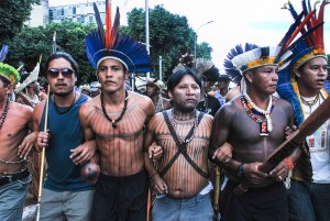
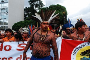
 The Munduruku are one of the largest ethnic groups in Brazil with a population of over thirteen thousand. For the last three centuries they have lived in the heart of the Amazon along 850 kilometers the Tapajós river in the eastern region of the state of Pará. This area is also home to the largest gold deposits in the world. The Tapajós is the last of the great Amazonian rivers without a dam but now the Brazilian government has approved plans for the construction of seven large hydroelectric plants on its river basin. These will have serious implications for at least one hundred indigenous settlements.
The main proposed hydroelectric plant, known as the Tapajós Complex, is in Sāo Luis de Tapajós. Constructio is scheduled to begin in 2017, to come online by 2020. It will flood out an area of 722,25 square kilometers, and will be the third largest dam in the country.
Most of the settlements along the river will be adversely affected by the dam, but it is undoubtedly the Sawré Muybu Indigenous Territory that will suffer the most. They will have to abandon their homes as the projected flooding will cover most of the area they consider their territory.
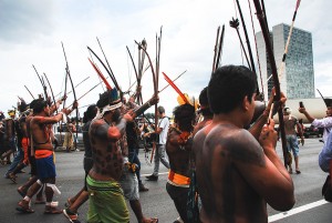
“That is exactly what they want. They want us as far away as possible from here. We are at war to defend our land. They will have to carry our dead bodies out of here,” said Rozeninho Saw in an interview with the Americas Progam.
“The Munduruku have always been known as great warriors,” he noted, recalling the tribe’s history. “In fact, the word ‘Munduruku’ refers to “red ants” because, like them, our ancestors left for battle well organized and attacked en masse.”
The federal government’s plan to expel the Munduruku from their ancestral lands goes against the constitution because the displacement of indigenous people is prohibited under Article 231. Article 231 recognizes the right of indigenous people to live permanently on their traditional territories. In an attempt to make the project legal, the Brazilian government has argued that the territory of the Sawre Muybu has never been officially, and therefore legally, recognized.
The government’s case, and along with it the plans for the hydroelectric project, has come under increased pressure due the disclosure of a seven-year study undertaken by the National Foundation of the Indian (FUNAI) that clearly outlines the historical inhabitancy by the Munduruku people of the territory in question as per the established guidelines of defining ancestral lands and sacred sites. The report, completed in 2013, proves the Munduruku’s claim to the land and establishes boundaries of the Sawre Muybu Indigenous Territory. It remained unpublished by the presidency of FUNAI until it was recently leaked to some media outlets.
The report concludes, “Based on an exhaustive investigation that addressed anthropological, ethnohistoric, cartographic, environmental, and topographic concerns, the working group fully recognizes the traditional character of the Munduruku people in the specified territory.”
Tapajós: Predominantly Indigenous
While non-indigenous communities are now increasingly populating the Tapajós area, the FUNAI report states that many parts of it still remain exclusively inhabited by indigenous people. Non-indigenous colonization can be traced back to the 19th century when the area absorbed many migrant workers catering to the rubber boom. This influx declined and ultimately stopped with the fall in the price of latex on the world market.
“Those migrants who remained and settled in the area, adapted to the indigenous customs and were assimilated into the community, not the other way round,” the study states. This lack of non-indigenous inhabitants is juxtaposed with the overwhelming presence of the Munduruku, and some other ethnicities predating the European conquest of the Amazon but little is known of their origins or history.”
Today, the region is still bereft of a significant non-indigenous presence. Most of the non-indigenous population is involved in illegal mining and overfishing.
FUNAI, the government body entrusted with establishing and implementing the nation’s indigenous policies, stipulates that there are a total of eleven Munduruku indigenous territories in the state of Pará. Ten of these are located along the margins of the Tapajós, however only two are officially recognized and geographically demarcated. The remaining territories are still undergoing this process of demarcation.
Tierra Madre
 The Sawré Muybu Indigenous Territory, as defined in report, encompasses an area of 178,173 hectares along 232 kilometers of the river through the municipalities of Itaituba and Trairão in the state of Pará. Where the Tapajós meets the Amazon River, four different tribes have settled (the Praia do Mangue, Praia do Índio, Sawre Apompu and Sawre Juybu). But it is the three main settlements (the Sawre Muybu, Ms Dace Watpu and Karo Muybu), which play a central and vital role for the whole Munduruku ethnic population. “We are a sort of mother ship for all the other settlements,” explains Rozeninho, “because our territory is the largest. The other tribes come here to get food and materials and to find someone to marry.”
The FUNAI report goes on to state that the central area of the Munduruku territory is host to many springs which feed into the Tapajós and which are “the source of habitats ecologically unique to the area in terms of flora and fauna (especially for hunting) and consequently offer the population of the Sawre Muyru an appropriate and vital source for nourishment and provide them with the raw materials needed for their tools and shelter.”
The Sawre Muybu IT also contains many of the Munduruku sacred sites, like the Igarapé Sāo Gonçalo and the Igarapé do Fecho, both of which will completely disappear underwater when, and if, the area is flooded by the dam. The small canal known as the Sāo Gonçalo, narrow but navigable, flows into the Tapajós at the exact location of the Ancient Village of the Munduruku. “This small canal is fundamental to one of the main rituals, known as the Tinguijada, of the Munduruku. It is also the source of many palm, copal, and patauá trees which attract many species the Munduruku hunt,” the FUNAI report specifies. Likewise, the Igarapé do Fecho, another small canal that flows into the Tapajós, is fundamental to the mythology of the Munduruku as they “believe it is the birthplace of the Tapajós,” adds Rozeninho.
According to a petition filed by the Federal Prosecutor asking the Supreme Court to suspend the license for the project on the grounds of it being a violation of the rights of the Munduruku, it lists the violation of sacred sites relevant to the beliefs, customs, traditions, symbology and spirituality of these indigenous populations, all of which are protected by the constitution, as its main reason.
The territory of Sawre Muybu coincides geographically with the Flora Itaituba II special conservation area. This alone should be grounds to impede it from being flooded. But in January 2012, President Dilma Rousseff ordered the scaling down in size of seven areas of special conservation, one of them being Flora Itaituba II . As a result, the unprotected area now falls squarely within the boundaries of the Munduruku territories and is now destined to become part of the reservoir formed by the dam. These perimeters were officially reduced and redefined by the government under the Medida Provisional (MP) n. 558/2012 which was formally passed into law n.12.678/2012.
From Tapajós To The World
The immense Tapajós River is comprised of a series of islands, lakes and lagoons that are rich in fish stock. It is also a major conduit for the transportation of Amazonian produce such as nuts, bacaba, burtiti and copal. Just at the point where the Igarapé do Fecho disgorges into the Tapajós, the main river narrows considerably due to protuberances on both sides of the bank. The bedrock is sheer granite, and large boulders and strong currents make the navigation of large boats almost impossible.
The seven planned hydroelectric projects will raise the water level, converting the river into a succession of reservoirs. This alteration will most certainly facilitate the navigation of the river for larger vessels. Given its strategic position connecting one of Brazil’s largest agricultural production (of soya and maize) with the newly established centers of mineral exploration (of gold and aluminum), traffic along the river will undoubtedly ramp up on a grand scale from the north of Pará, onto the Amazon River, and out towards the Atlantic Ocean.
These hydroelectric plants are thus seen to be a key component to the exploitation of the minerals in the region. “They are fundamental to the functioning of the industry because they will provide them with the electricity necessary to run the mines. “In reality this completely negates the rights of the people who inhabit the region,” Nayana Fernandez, director of the documentary “Indigenas Munduruku: Weaving Resistance” and activist for the indigenous of the region, told CIP Americas.
China: Eletrobrás Furnas, closely tied to the Federal Ministry of Mines and Energy, recently signed a memorandum of cooperation with China Three Gorges International Corporation (CTG) to build the Sāo Luis do Tapajós Hydroelectric Dam. This agreement consolidates the company’s strategy of positioning itself among the largest energy producers in the world.
Minerals For the World
 The proliferation of gold prospecting and mining is another factor adding to the growing environmental crisis in the Tapajós region. Known to have the largest untapped deposits in the world, gold nevertheless has been mined in the region since the 1950s, the FUNAI report states. “In the 1980s the municipality of Itaituba was the largest gold producer in the world, extracting an estimated ten tons per month,” according to the Office of Mining and the Environment of Itaituba and the Tapajós Association of Gold Producers.
Data provided by the Department of Mineral Production (DNPM) and analyzed in the FUNAI report shows that an official permit for gold mining issued was issued in 2013 to the Miners Association of the Amazon, which guarantees the legitimacy of the licenses on file at the DMPM. No less than 94 of these licenses infringe on the territorial rights of the Sawre Muybu IT.
In 2012 the Institute of Socioeconomic Studies published a report stating that in the decade between 2000 and 2010 exports from the region officially designated the “Legal” Amazon increased much more the exports from other Brazilian regions, namely by 518% versus 366%, or from 5,000 million dollars in 2000 to 26,000 million in 2010.
The state of Pará was itself responsible for 48% (or 12,800 million dollars) of the total value of exports in 2010. The schedule of exports details the predominance of minerals, followed by farming produce, and meat in particular. Three companies – Vale, Alunorte, and Albrás (aluminum and iron ore) – accounted for 78% of the export market value, or 10,000 million dollars, in the state of Pará.
Aluminum mining consumes almost 6% of the energy generated in the Brazil. According to Celio Bermann, “aluminum is sold at a relatively insignificant price on the international market and generates negligible employment figures. The work force employed by the aluminum production industry is 70 times smaller than the work forced generated for the food and drinks industry, and 40 times smaller than that employed by the textile industry.”
In Brazil, transnational companies that control 70% of its distribution and 30% of its production primarily provide for energy. 665 companies consume 30% of the total energy produced by the hydroelectric plants.
Records show that over 2000 hydroelectric dams have been constructed up until the year 2012. Over a million people have been expelled from their homes and land as a result; 70% of them without being indemnified in any way. China, Spain and the United States were the biggest investors in Brazil in 2014. According to the CEPAL, the Economic Commission for Latin America and the Caribbean, Chinese foreign direct investment topped 1,161 million dollars in 2015, mainly due to increased investment in oil, electrical distribution and manufacturing.
Impact
Although work has not yet begun in Tapajós, the Munduruku are already subject to the impact of the project on their lives on a daily basis. “The simple act of not publishing the report specifying the demarcation lines of the Sawre Muybu territory is an important impact of the project on the community. As is the process of self-demarcation of their sacred lands, undertaken by the indigenous communities themselves. They have been forced to go down this route in order to defend the concept of what it means to be Munduruku in light of the fight for the right to remain in the land of their ancestors,” says Nayana Fernandez. She goes on to say that the Munduruku’s prime focus and main weapons in the fight are the experiences of other traditional communities who have already been subject to the myriad effects of the hydroelectric plants in their midst as well as the dire warnings of environmental disaster issued by many studies and reports.
 Hydroelectric dams in other rivers – the River Teles Pires, or the Belo Monte Dam in the Xingu River, for example – are prime examples of the most extreme of consequences.
“In order to build the Teles Pires Dam, construction companies dynamited the waterfalls known as “Sete Quedas (Seven Falls)” which were a sacred site for the Kayabi, the Apiaka, and the Munduruku. They were allowed to commit this ethno historic crime without having had any prior consultation with the local communities, as is required by the Convention No. 169 of the International Labor Organization to which Brazil is signatory,” she asserts.
The landscape will be altered dramatically, as will the behavior and flow of the river and its tributaries. This will, in turn, create social and economic problems, not least through the appropriation and segregation of large spaces to specifically and exclusively designate them for the transport of materials, for the warehousing of produce and for waste management.
FUNAI’s impact report details alterations in the level and direction of the river; the denuding of vegetation and habitats for fauna, specifically in forested areas and in freshwater marshes and wetlands; the severe interference in the migration routes of fish, and the increased endangerment of animal species, among them: manatees, freshwater dolphins, pink porpoises, caimans, Amazonian turtles, amarillos, otters, and lizards unique to the environment. The flooding will furthermore result in the disappearance of the islands, lagoons, and freshwater swamp forests that surround the Tapajós River, and consequently in the disappearance of their unique habitats too.
No Funding For The Recognition of Ancestral Lands?
In May 2014 the public prosecutor lodged a case in the Federal Court of Itaituba against FUNAI for delaying the demarcation process of the Sawre Muybu Indigenous Territory. The Munduruku met with Maria Augusta Assirati, ex- president of FUNAI, in Brasilia in September of 2014. It was at that meeting that she admitted that the delay in the publication of the report was due to interference from various branches of the government with interests in the hydroelectric project.
The public prosecutor proceeded with his case in the courts insisting on legal territorial demarcation for the Sawre Muybu well into 2015. Eventually the court ruled that FUNAI was legally obliged to continue with the process of certifying and demarking the territory. It was further stipulated that until FUNAI complied, the organization would have to pay a daily fine of 900 US dollars to the Munduruku. FUNAI has appealed the decision but as yet there has been no final ruling.
According to the arguments presented in court by the public prosecutor, FUNAI maintained that priority in the national demarcation process of indigenous lands had been allocated to the indigenous territories of the south and southeast and that there were no available public funds for the same process in the Amazonian region. The prosecutor rejected that argument saying that public funds were utilized for the preparation of the report, therefore they were available.
“It would be a waste of public money if the report were archived after the great investment incurred in its preparation and, above else, the unquestionable violation of the constitutional rights of indigenous people that would result if that were to occur,” said the prosecutor Camoēs Buenaventura.
Guarding Ancestral Territory
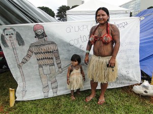
 Munduruku art has as its central motif the figure of the Jabuti, an Amazonian turtle. Legends say the animal’s shrewdness and community spirit helped it defeat its most feared enemies.
“We have to use our own wisdom to quench the attempted extermination of our people. The enemies of the indigenous communities behave like the Great Anaconda who clasps her victims so hard their bones crush before suffocating them. But Jabuti gave us a lesson in how to defeat them,” say the Munduruku in a letter signed collectively.
The Munduruku’s last resort has been to self-demarcate their ancestral lands. The first step taken to recuperate and reclaim the territory as their own was in October of 2014, using as their geographical point of reference the same territorial limits as those outlined in the FUNAI report. Precisely because the federal government did not officially recognize this report, the Munduruku felt compelled to uphold the position articulated in it.
“The self-demarcation of the Sawre Muybu Indigenous Territory is a resistance movement against those developments proposed by the government and foreign multinational companies in the Amazon. These include hydroelectric dams, the exploitation of the forest, and the expansion of the agroindustry. It also represents the organization of the indigenous people to collectively guard against and protect the rights of the indigenous communities in light of the illegal occupation of their lands and the continued abuse of their natural resources,” their letter continues.
The Munduruku have recently issued a second salvo in the quest to recuperate and reclaim their territory. In July 2015 they wrote, “We have unquestionable evidence of the manmade destruction of our fruit producing trees. We take care of these trees because not only do we eat the fruit, they are the future we will leave to our grandchildren. We can see that there are not many left, almost none on our lands. The fruit provides nourishing juice for our children and all we can see is its decimation. We have always said that the pariwat (the white man) is not aware of any of this. This is why we are engaged in this process of self-demarcation. We do not think as the pariwat who is destroying our trees thinks.”
According to Rozeninho, the Munduruku are convening a general meeting for September 2015 to evaluate the progress of the campaign so far and to discuss what future steps they will take.
Photos by Santiago Navarro F.
Translation by Isabella Weibrecht